Covering Mineral Exploration in the Nordics

Northern Explorer Scandinavian Exploration and mining news logo

Mineral Exploration Consultancy

Mineral Exploration in Finland: A Short Guide to Get You Started⛏️🗺️ 🇫🇮

This article is intended to make life a little bit easier for everyone interested in mineral exploration in Finland. We’ll start with a brief overview of the country’s raw material sector and a look at some of the most important legislation before sharing the best ways to access geological, geographical, and cadastral data. Be sure to check out our new free resources page where we will add more and more useful content going forward.

The Finnish Mining Industry⚒️

Home to the EU’s largest gold mine, its only chromite mine, its largest cobalt refinery, and blessed with one of the best managed and regulated exploration sectors, the Finnish mining idustry is of strategic importance for the raw material supply and independence of the union.

Finland has currently eight active metal mines and several larger, advanced-stage projects that are expected to come online within the next few years. These include the Sakkatti magmatic nickel sulfide deposit, the recently discovered Ikkari gold deposit, the Keliber lithium project and the Sokli rare earth – phosphate project.

Over the years, the country’s well-developed mineral exploration industry, its highly prospective bedrock, and recent major discoveries (Sakkatti, Ikkari) attracted substantial interest from major mining companies like Anglo American, Agnico Eagle, Boliden, Sibanye Stillwater, and BHP to name a few.
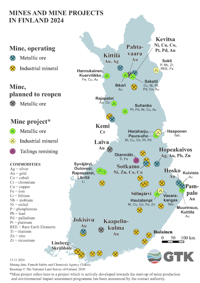
Active mining operations and advanced stage projects in Finland, stand 13.11.2024 (gtk.fi)

Statistics 📊

Finland is of key strategic importance for several commodities to the European Union. The country for example controls almost 90% of the inner European nickel production and around 90% of the EU’s cobalt refining market.

Recently, Finland also became the union’s only producer of uranium which is expected to supply about half the country’s uranium needed for its nuclear power plants during the next years.
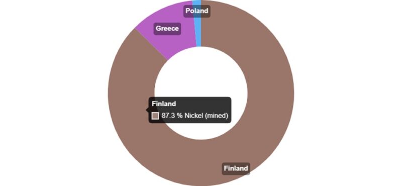
EU primary nickel producers. Data from 2023. Source: (rmis.jrc.ec.europa.eu)

In terms of exploration expenditures, Finland has attracted more and more investments and has been outperforming the global average over approximately the last 10 years.
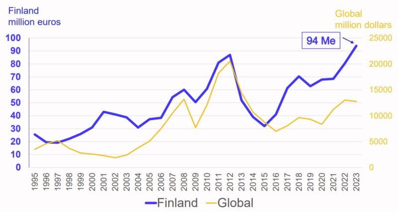
Statistics on Exploration in Finland 2019-2023. Source: (tukes.fi)

This trend is also visible in a further breakdown of TUKES’s exploration-related data shown below. In addition to for example the size of landholdings, the statistics also provide some information on drilling meters, which are probably one of the best indicators to assess the health of a country’s exploration industry. While I don’t know how exactly TUKES defines Grassroot, Greenfield, and Brownfield drilling, the data appears to indicate that a lot of the money in Finland goes to finding completely new deposits as opposed to brownfield exploration.

Statistics on Exploration in Finland 2019-2023. Source: (tukes.fi)

Responsible Authorities🏛️

In Finland, everything related to exploration and mining is essentially managed by the Geological Survey of Finland (GTK) and the Finnish Safety and Chemicals Agency’s (TUKES) mining department. While the GTK, among others, focuses on bedrock and mineral resources, TUKES is the licensing and supervisory authority, dealing with, for example, issuing exploration permits.


Governing legislation⚖️📜

The primary laws governing mineral exploration and mining in Finland are the Mining Act and the associated Government Decree. On June 1st, 2023, several amendments (505/2023) to the Mining Act entered into force. Among the most important changes were the amendments to the reservations (limited size, introduction of a fee), giving municipalities more rights, and forcing exploration permit holders to run yearly town hall meetings to keep the residents updated on the latest work programs.

While these changes sound like more work and high costs for the industry, they also remove less serious actors from the game, thus hindering, for example, the blocking of large areas of the country for strategic reasons.

As in Norway and Sweden and depending on the location and nature of the planned activities, there are, of course, other laws and regulations that must be considered, not only at the national level but also at regional and local levels. Some of the more commonly referred to laws include the Reindeer Husbandry Act and the Environmental Protection Act.


The permitting system

The Finnish system works with a reservation and exploration permit. The former allows you to dconduct simple prospecting work like geological sampling and mapping and gives you the priority right to apply for an exploration permit in a certain area, whereas the latter is needed to conduct more extensive exploration work like trenching or diamond drilling and gives the permit holder a priority right to apply for a mining permit.

The fees are 1 euro per hectare for the reservations and 20 euros per hectare for the first four years of a valid exploration permit. During years five, six, and seven, the fee increases to 30 euros, during years eight, nine, and ten to 40 euros and during years eleven to fifteen (the last year) to 50 euros per hectare.

While the landholding fees are significantly more expensive than in Sweden or Norway, they are paid directly to the landowners and not the state, thus directly benefiting the affected stakeholders.

The recent changes in the mining code also affected the permitting situation. Among others, the reservation area is now limited in size and comes with the abovementioned fee of 1 Euro per hectare and extensions of exploration permits beyond year 10 require the consent of >50% of the affected landowners.

More information on the permitting system and the forms to file reservation and exploration permit applications can be found here.
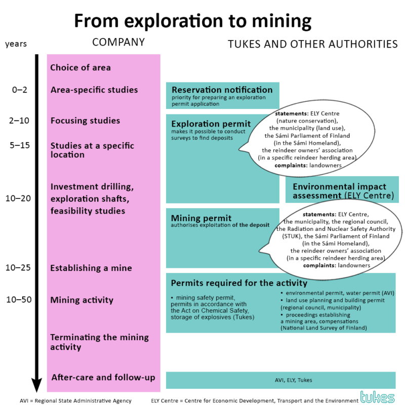
Finnish Permitting System Overview. Source: (tukes.fi)

How to Access Data📂

Now, let’s move on to the most practical part of the article – how to access the key datasets for mineral exploration in Finland.

In Finland, the best starting point is the online map viewer from the geological survey. With the ability to overlay essentially everything from bedrock maps to permits, drilling data, geophysics, and mineral occurrences, it’s in our view the best viewer from all the different Nordic countries.

If you want to download the latest permitting data or set up links to a WMS server you can do so via this page on Tukes website. In Finland, it is also possible to get access to the expired claims which is, as explained in other articles, a rather helpful tool.

GTK map viewer interface. The picture shows the historic exploration claims in the Central Lapland Greenstone Belt. Source: (gtkdata.gtk.fi)

Geological Data ⛏️

If you just want to have a quick overview of the geology in an area of interest it is best to simply use the GTK’s map viewer. The data visualized in the map viewer can also downloaded using the GTK’s portal for spatial data products.

If you want to get access to older maps of a certain area you can have a look at the following page. To populate the search mask it can be helpful to know under which map sheet your area of interest falls, which can be looked up here.

If you are looking for additional reports or other, old geological and exploration-related data you can conduct a search using the publications, reports, maps, and posters page.

GTK map viewer showing the bedrock map of Finland. Source: (gtkdata.gtk.fi)

Geophysical Data 🧲

In Finland, some of the geophysical data can be visualized using GTK’s Mapviewer. If, however, you prefer to download the datasets, you have to filter the Spatial Products Sections at Hakku for geophysics. Here, you can download most of the data for free, even though some datasets might be available only for a fee. The data can either be downloaded or accessed via establishing a WMS connection.

Snapshot of the survey’s map viewer. Available geophysical data can be visualized in the viewer. Source: (gtkdata.gtk.fi)

Geochemical Data ⚛️

As for geological and geophysical data, you can have a look at the national database using GTK’s map viewer and plot for example regional till geochemistry.

If you want to link the datasets or download the raw data you can do so, again, via Hakku’s Spatial Data Products section by filtering for Geochemical datasets.

Snapshot of the survey’s map viewer, showing regional till geochemistry for copper. Source: (gtkdata.gtk.fi)

Basemaps & Elevation Data 🗺️⛰️

One of the most popular ways to access topographic maps, elevation models, or aerial photos is through the National Land Survey of Finland. The website offers a great map viewer that allows you to visualize and overlay a range of important background and cadastral datasets. More importantly, toggling the sidebar on the right will also allow you to download most of the data for free. Here you can find for example DEM with 2m resolution, background maps, and aerial photos pretty much in all the formats you need for QGIS or Leapfrog.

There are of course also ways to access the data as WMS. The survey provides free-of-charge links but there is also possibility to sign the an agreement to access better datasets. More information on how to sign up and regarding the free links can be found here.


Property boundaries and IDs are visualized using GTK’s map viewer. (gtkdata.gtk.fi)
Property boundaries and IDs are visualized using GTK’s map viewer. Source: (gtkdata.gtk.fi)

Environmental protection status ♻️

The easiest way to get an overview of any potential protection status of a certain area is to plot the nature conservation areas using GTK’s map viewer. WMS links o for example the Natura 2000 areas can be found at the Finnish Environmental Institute. Here it’s, also possible to directly download some of the datasets.

GTK map viewer with nature conservation areas. Source: (gtkdata.gtk.fi)

Reindeer Herding 🦌

As in Norway and Sweden, the northern part of Finland is a traditional reindeer herding area. Similar to other countries, reindeer herding in Finland is managed within distinct, spatially separated areas known as herding cooperatives. These cooperatives are part of the larger reindeer herding organization. More information on this topic can be found here. The website also includes a link to a map viewer that visualizes the different reindeer herding cooperatives.

Overview map of the Finnish Reindeer Herding cooperatives. Source: (paliskunnat.fi)
Historic Drill Core

Most of Finland’s now more than 3.6 million meters of historic drill core is stored at the national core archive in Loppi in southern Finland. There is, however, also a facility in Rovaniemi, facilitating exploration in some of the most prospective parts of the country.

The drilling can be visualized using the GTK’s map viewer. If you want to download the data, you can do so via Hakku. If you would like to receive, for example, also assay or logging data you may do so by contacting GTK and against a fee. More information can be found here.

GTK’s map viewer with the bedrock drilling layer. Source: (www.gtkdata.gtk.fi)

Cultural Heritage

Another important consideration is whether your area of interest contains any significant, protected historical sites. Depending on the specific site, you may need additional permits or exemptions to carry out your work. The best way to get some information about potentially protected sites is by setting up a WMS connection using the links provided by the Finish Heritage Agency.

Other useful links 🔗

It is also worth noting that in addition to providing all the data and services mentioned above, GTK also has top-of-the-art facilities to conduct for example pilot scale testing to support more downstream studies of mineral deposits. More information on what exactly GTK can offer via its Mintec subunit can be found here.

As mentioned already in the other guidebooks, having an idea of snow coverage and mobile connection before going out in the field can be a good idea. A snow coverage map for Finland can be found for example here, Other than in Sweden or especially Norway, the connectivity in Finland is better, thanks to the country’s generally flat terrain, with only some blank spots remaining in the north of the country. While there are several providers, the coverage is more or less the same, so checking for example with DNA should give you a rough idea about the signal quality in your area.

Snow coverage map Finland. Source: (wwwi2.ymparisto.fi)

Hope this helps to get you started and please make sure to check out our free resource page, where we will post more useful content going forward.

/The Northern Explorer