

In this article, we take a closer look at the Knaften Gold Project, currently being advanced by TSX-V-listed Gungnir Resources. The project is situated at the southernmost extent of the so-called Swedish Gold Line and lies up-ice of a prominent glacial till anomaly, which has historically drawn geologists to the region. We’ll begin with an overview of the project’s history before examining the extent and geometries of the mineralization in more detail. As usual, this second part will be available to premium subscribers, and my 3D model will be accessible to exclusive members.
Project location
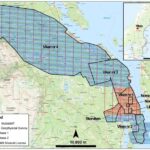
The project is generally considered to represent the southernmost extent of an anomalous trend of geochemical anomalies that loosely define an area commonly referred to as the ‘Gold Line.’ It is located up-ice of a strong glacial till anomaly, the source of which has yet to be defined.
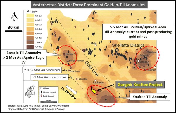
Gold line till anomaly map. Source: (gungnirresources.com)
Knaften Project History
The first evidence of gold mineralization dates back to the 1980s, when the glacial till data identified a geochemically anomalous zone south of Lycksele.
From what I was able to gather by searching through various databases, the first drilling at the project took place in the late 1990s, conducted by NAN—a former Lundin company active in Sweden during the late 1990s and early 2000s. This was followed by additional drilling campaigns carried out by Lappland Gold Prospectors in the early 2000s. Gungnir Resources appears to have acquired the initial claims around 2016 and subsequently conducted several drilling campaigns between 2017 and 2021.
To date, over 100 drill holes have been completed at the Knaften property, totaling more than 15,000 meters—possibly closer to 20,000 meters (not all the data is readily available).
In recent years, activity at the project has slowed, with Gungnir shifting its focus toward its nearby nickel projects. However, the company now appears to be refocusing on the broader Knaften area, though drilling at the project’s primary mineralized zone has yet to resume.
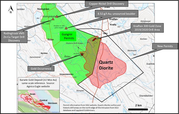
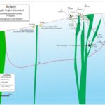
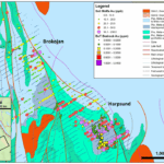
Knaften overview map. Source: (gungnirresources.com)
Historic Drilling & Mineralization
Historic exploration efforts have primarily targeted a quartz diorite intrusion, where auriferous sulfide mineralization—dominated by arsenopyrite—has been identified at multiple locations. A significant portion of past drilling has focused on the so-called Knaften 300 zone, located at the northern edge of the intrusion.
Interestingly, all the mineralization identified so far appears to be largely confined to the intrusion’s margins rather than its core.
Reviewing the historical assay data reveals some notable drill intersections, including:
· 3.45 g/t Au over 10.75m in hole 96009 (NAN)
· 3.20 g/t Au over 10.00m in hole 200707 (Lappland Guldprospektering)
· 14.07 g/t Au over 4.25m, including 59.6 g/t Au over 1.00m, in hole KN19-06 (Gungnir Resources)
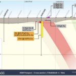
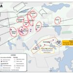
Gungnir Resources currently interprets the gold mineralization at the Knaften 300 zone as multiple, nearly flat-lying, stacked mineralized zones, each generally a few meters thick. While the mineralization appears to be relatively continuous, gold grades vary significantly along these zones.
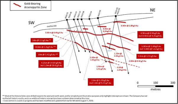
Knaften 300 gold zone cross section. Source: (gungnirresources.com)
The most recent drilling campaign took place in 2021, leading to further extensions of the Knaften 300 zone. Since then, activity at the project slowed, with the only notable development being an IP survey conducted over other parts of the intrusion. To my knowledge, the results of this survey have yet to be followed up.