This article is intended to make life a little bit easier for everyone interested in mineral exploration in Sweden. We’ll start with a brief overview of the country’s raw material sector and a look at some of the most important legislation before sharing the best ways to access geological, geographical, and cadastral data. Be sure to check out our new free resources page where we will add more and more useful content going forward.
The Swedish Mining Industry⚒️
Home to major mining companies like Boliden and LKAB and world-leading mining equipment manufacturers such as Epiroc, Sandvik, and Atlas Copco, Sweden is undoubtedly one of Europe’s most important mining nations.
The country currently has around a dozen active metal mines, producing both base and precious metals, and has a handful of advanced-stage projects that are projected to add to Sweden’s production of iron, copper, graphite, rare earth elements, and perhaps uranium in the future.
In recent years, especially following the election of a new government in September 2022, the Swedish mining industry has received increasing support for addressing issues that have been slowing down exploration and decision-making in the past.
Probably the most important change is the clarification of the stage in the mine permitting process when a Natura 2000 permit needs to be obtained. For those interested, I’ll refer to this brief article from Svemin. In addition to these major changes, the exploration sector has recently profited from reforms in the law concerning additional deep drilling permits and the regulation of offroad driving.
Last but certainly not least, the adoption of the Critical Raw Materials Act is expected to provide significant support to the European, and thereby Swedish, mining industry. As a direct consequence, a number of companies with projects in Sweden have recently applied for strategic project status under the Act, something that – if granted – is expected to further streamline the permitting process and define clear timelines to production.
Statistics 📊
Sweden has been a stable producer of a wide range of commodities for centuries. Today the country’s mines are responsible for more than 90% of the EU’s iron production, almost half of its lead production, and around one-third of its zinc production, in addition to being one of the most important copper producers.
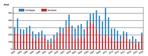
While exploration expenditures have risen to nearly 200 million USD in recent years, the number of issued exploration permits has declined from a peak around 2007–2008.
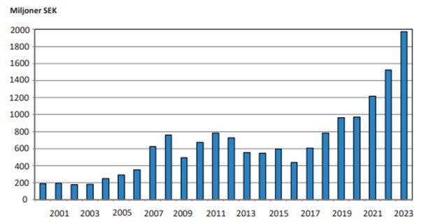
Although this is speculative on our part, this disparity could indicate a clear preference for advanced-stage projects over new greenfield opportunities.
Responsible Authorities🏛️
In Sweden, the responsible authority for mineral exploration and mining is the Swedish Geological Survey (SGU) along with the mining inspectorate, a subordinate unit that handles various tasks, including issuing exploration and mining permits. The Geological Survey operates under the Ministry of Climate and Business.
Governing legislation⚖️📜
The primary laws governing mineral exploration and mining in Sweden are the Minerals Act (1991:45) and the associated Mineral Ordinance (1992:285) (English translations can be accessed here and here). The Minerals Act outlines everything from which minerals are seen as concession minerals, to the functioning of the permitting system and how exploration work should be conducted.
Depending on the location and nature of the planned activities, there are, of course other laws and regulations that must be considered, not only at the national level but also at regional and local levels. Some of the more commonly referred to laws include the Reindeer Industry Act (1971:437) or the Environmental Code (1998:808).
The permitting system✅
In Sweden, the permitting system operates on a first-come, first-served basis and is designed to allow exploration permits to be held by a single party for a total of 15 years before a mining concession application must be submitted. The 15-year period is divided into three-year intervals, with progressively increasing landholding fees and heightened expectations regarding the amount and nature of exploration work completed during each period.
Although the permitting process in Sweden functions effectively, it does not yet offer the convenience of an online application interface, as is the case in Norway. As of today, a series of PDF forms have to be downloaded from the Mine Inspectorates Website, filled out, and then sent back to the authorities.
Conducting exploration work👷
Similar to the system in Norway, a valid exploration permit does not actually grant the right to conduct all types of exploration activities. Some non-invasive work, such as ground magnetic surveys, is generally permitted without the need to submit a work plan. However, for more invasive activities, such as diamond drilling, a work plan must be prepared and distributed to the affected stakeholders. This plan must gain legal validity before any work can commence.
Additional Permits associated with a work plan 🔎
Often, additional permits are required in addition to a valid work plan before work can begin. The specific permits are highly dependent on each case and can for example, include permits or exemptions to drill in the vicinity of residential buildings or drilling underneath a public road. As this can get rather complex it’s best to consult with one of the expert consultancies, specialized in permit-related matters in Sweden.
How to Access Data📂
Now, let’s move on to the most practical part of the article – how to access the key datasets for mineral exploration in Sweden.
In Sweden, the best starting point is the online mapviewer from the geological survey. While it doesn’t allow for unlimited layering, using features like the “ore and mineral” layer enables you to plot mineral permits, the bedrock map, and all known mineral occurrences in the country.
The permit viewer also has the ability to highlight incoming applications and, importantly, store all historical permits. This is a particularly valuable feature, as it allows you to see who has previously worked in a given area. Often, this information includes direct links to historical exploration data.
If you want to download the latest permitting data or set up links to a WMS server you can do so via this page on the survey website.
Geological Data ⛏️
If you simply want to visualize the geological data, start by exploring the previously mentioned map viewer, but this time filter by the different bedrock maps. There is also the possibility to add different structural geological datasets.
If you prefer to download the data or set up your own link connection, it’s best to check SGU’s online database, GeoLagret. Here you can find everything from old mine maps in PDF format to WMS links for bedrock geology on different scales.
Geophysical Data 🧲
Accessing geophysical data in Sweden can be approached in several ways. The first step usually involves getting an overview using the survey’s map viewer. The viewer allows you for example to display processed maps of countrywide airborne magnetic or gravity data. It also allows you to check what types of geophysical surveys, either airborne or ground-based, have already been conducted in your area of interest.
If you want to access the data via WMS it’s best to use the links provided under Geolagret>Produkttyp>Karttjänst. If you want to access some of the historical data in your area of interest, and cannot find the data on Geolagret or linked to the historic permit file in the Map viewer, it’s worth contacting the SGU’s mineral information office in Malå.
It is also important to note that not all data available to the SGU has been digitized. SGU’s facilities host extensive paper archives containing a wealth of historical data that has yet to be converted into digital formats. These archives may hold valuable information, potentially offering clues to new discoveries.
Geochemical Data ⚛️
Similar to geophysical data, the available regional geochemical datasets can be visualized using the SGU’s map viewer. You can choose between rock or soil geochemistry.
If you want to link the datasets or download the raw data you can do so, again, via Geolagret. Simply type in “geochemie” in the search mask and the two datasets should appear.
Basemaps & Elevation Data 🗺️⛰️
One of the most popular ways to access topographic maps, elevation models, or aerial photos is through Lantmäteriet, the Swedish mapping authority. Some of the data is free while other datasets might be subject to a fee. That said, with some new EU regulations in place there is a good chance that more and more data will eventually be accessible for free. The free data includes for example Lidar datasets, other elevation models, and historic aerial photos. To access the data you will need to make an account with Lantmäteriet to be able to access their Geodataportal and later on, use the data in your GIS software if you plan to use direct links.
Landownership 🚧
When it comes to seeing the property boundaries in Sweden the best way is to open Lantmäteriets map viewer and toggle on the property boundaries. Accessing information on who owns a property is more difficult, especially in the case of large amounts of datasets, commonly used in exploration. You can find more information on the topic here. In short you either have to get the data from Lantmäteriet directly, from one of their resellers, or contact one of the local consultancies.
Environmental protection status ♻️
The quickest way to assess an area’s protection status is by using Naturvardsverket’s map viewer. The viewer allows you to visualize the protection status of a selected area, including for example Natura 2000 areas or the protected mountain ranges. If you want to get the data as shapefile or WMS you can do so via this page.
Reindeer Herding 🦌
As in Norway and Finland, the northern half of Sweden is traditional reindeer herding area. The best resource to learn more about this topic is the Sami Parliament’s website. There, you can explore detailed information about reindeer herding and use an online map viewer to visualize the various herding districts and related data.
Historic Drill Core
Sweden’s drill core archive is located in the small town of Malå, situated in the central Skellefte ore district in the northern part of the country. Currently housing over 3.5 million meters of drill core, the archive has recently been expanded to accommodate additional samples. It also features three core logging rooms available for daily rental through the Geological Survey.
Drilling data can be visualized online, using the map viewer or accessed via GeoLagret.
Cultural Heritage
Another important consideration is whether your area of interest contains any significant, protected historical sites. Depending on the specific site, you may need additional permits or exemptions to carry out your work. A useful way to access this information is through the provided link. If you want to download the data or obtain the WMS links, visit Riksantikvarieämbetets website.
Other useful links 🔗
One extra exploration layer worth mentioning is the Mineral Hunt, where prospectors can submit samples of mineralized outcrops or boulders for a chance to win prizes for the best finds. This initiative has raised public awareness and contributed to a valuable dataset with the potential to support new discoveries. After a hiatus of several years, the Geological Survey has recently restarted the Mineral Hunt. The dataset should be available upon request from the geological survey.
As in Norway, having a map showing the current or historic snow coverage can be valuable when planning exploration campaigns. Mobile network cover in Sweden is generally pretty good but it’s always worth having a look at the coverage situation, especially if you are planning to work in the more mountainous regions of the country.
Hope this helps to get you started and please make sure to check out our free resource page, where we will post more useful content going forward.
/The Northern Explorer