This article is intended to make life a little bit easier for everyone interested in mineral exploration in Norway. We’ll start with a brief overview of the country’s raw material sector and a look at some of the most important legislation before sharing the best ways to access geological, geographical, and cadastral data. Be sure to check out our new free resources page where we will add more and more useful content going forward.
Norwegian Mineral Strategy 🇳🇴
In 2023, Norway published its new Mineral Strategy, underlining the government’s recognition of a need for domestic production of raw materials from a sustainable and geopolitical standpoint.
In short, the strategy outlines the country’s plans to develop the world’s most sustainable raw materials sector in close collaboration with similar international initiatives, like for example the European Union’s Critical Raw Materials Act. To achieve these ambitious goals, the country defined several focus areas, including, faster implementation of mineral projects and improved access to mineral project financing.
Statistics 📊
Although Norway has a rich mining history, hosting major deposits such as Lokken (24Mt @ 2.3% Cu) and larger discoveries like Nussir, the Nordic nation’s focus over the last decades has been on its oil and gas sector. Today, only two metal mines are operating in Norway – a titanium mine in the south and an iron ore operation in the central parts of the country.

In recent years, however, the country has seen a boom in exploration activities, with many new actors entering the stage. Norway has also caught the attention of major mining companies, with BHP recently forming an exploration alliance with Kingsrose Mining, a junior company focused on the underexplored northernmost regions of the country. The graphic below visualizes this uptick in exploration activities, albeit the most recent increase is mostly related to a single company staking large parts of the country.

While the landholding numbers do not necessarily indicate substantial exploration activities, the upward trend is confirmed by the increase in exploration spending, as illustrated in Dirmin’s graphic below.

Responsible Authorities🏛️
In Norway, the responsible authority for mineral exploration and mining (on land – seabed mining is a different story – some initial insights here) is the Ministry of Trade, Industry and Fisheries. While the ministry is the governing authority, most of the day-to-day decisions are handled by the Directorate for Mineral Management (Direktoratet for mineralforvaltning, Dirmin).
Governing legislation⚖️📜
The Minerals Act 📜
The primary law governing mineral exploration and mining in Norway is the Minerals Act, which provides the framework for conducting mineral exploration, covering everything from the permitting system to how exploitation is regulated. Notably, the act differentiates between state and landowner minerals. A unique difference between Norway and most other countries with similar divisions is that certain minerals, such as lithium and graphite are defined as landowner minerals. The distinction between landowner and state-owned mineral has previously been the cause of conflict but has recently been clarified to some extend in a court ruling concerning the Engebo Garnet-Rutile deposit.
There are of course also other important legislations that apply when conducting exploration work in Norway. To name a few, everyone working in Norway should be aware of the Reindeer Herding Act, the Outdoor Activities Act, the Motor Traffic Act, and associated regulations.
Updates to the Minerals Act 🔄⚖️
With regards to the Minerals Act, it is worth noting that Norway is currently working on a larger assessment and update of the Minerals Act (Nou 2022:8), to better align it with the Ministry of Trade and Fisheries general objective to facilitate overall value creation within a sustainable framework.
While these proposals are still under review and there is no guarantee that they will be fully or partially adopted, the document outlines some interesting changes. An important proposal is a change in the permitting system, away from annual renewals to permits issued in three-year blocks with each renewal subject to increasing exploration expenditures, aligning somewhat with the Swedish system.
Although there has been no official statement on when the proposal will be brought before parliament, rumors suggest that this might happen during the summer of 2025.
The permitting system✅
To apply for an exploration permit, a business must be listed in the Norwegian Business registry. The permitting system in Norway generally operates on a first-come, first-served basis with annual fees required to retain the priority rights over the state’s minerals in a specific area. Details about the fees and the exact process can be found on Dirmin’s website.
When it comes to the actual application process, Norway stands out thanks to its recent implementation of a user-friendly online permitting portal. Once logged into the portal you can apply within minutes by yourself. Currently, it is only possible to select rectangles aligned to the UTM grid lines, but we are hopeful to see the ability to apply with more complex shapes in the near future (@Dirmin).

Conducting exploration work👷
As in many countries with a well-developed metal mining industry, an exploration permit in Norway does not automatically grant the right to begin exploration activities. The additional permits required to conduct your work generally depend on two key factors: the location of the area of interest and the nature of the planned exploration activities.
Searches and Investigation 🔎
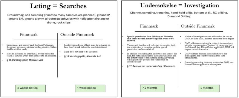
Exploration work in Norway is typically classified as either searches or investigations, with the latter being more “invasive” in a way that it might involve larger machinery or more extensive surveys. To give a few examples, searches usually involve chip sampling, most ground and airborne geophysics, and limited geochemical sampling programs, while common examples for investigation work would be diamond drilling or trenching.
Depending on which category your planned work falls under, you will either only have to inform the stakeholders (searches) a little while in advance, or hand in a detailed workplan in case of more detailed investigation work.
If you plan to explore in Finnmark, the northernmost part of the country, the rules differ. For instance, conducting investigation work in this region requires special permission from the Ministry of Fisheries and Trade. More information on work in Finnmark can be accessed here.
How to Access Data📂
If you made it this far in the article without falling asleep, chances are you are a geologist eager to take a closer look at Norway. Since figuring out how to access different datasets and locate additional information on specific topics related to mineral exploration in Norway can be time-consuming (we’ve been there ourselves!), we hope the following section proves helpful.

